Posts mit dem Label Custom Maps werden angezeigt. Alle Posts anzeigen
Posts mit dem Label Custom Maps werden angezeigt. Alle Posts anzeigen
Mittwoch, 11. April 2012

Sonntag, 1. April 2012
Mittwoch, 23. März 2011
Montag, 20. Dezember 2010
Dienstag, 6. April 2010
The Smartest Way to Find a Cab
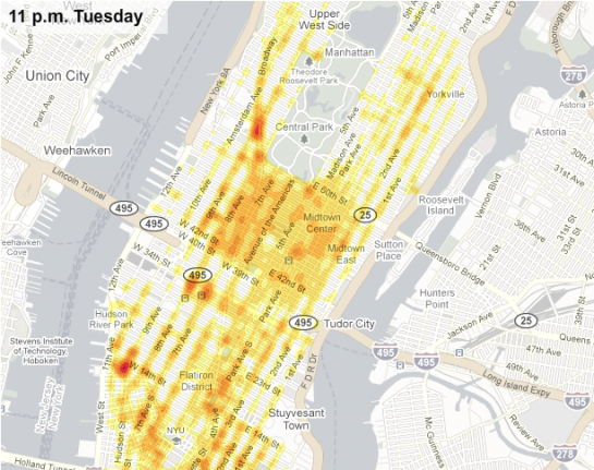
- CabSense analyzes tens of millions of GPS data points from NYC taxis to help you find the best corner to catch a cab
- Use Map View or Radar View to find the best corner
- Plan ahead with the Time Slider and see the best locations at a future timeCabSense New York: The Smartest Way to Find a Cab
via http://flowingdata.com/2010/04/05/best-place-to-catch-a-cab-try-bloomingdales/

Donnerstag, 18. Februar 2010
Dienstag, 19. Januar 2010
Donnerstag, 23. Juli 2009
Layers in Google Maps Mobile
Official Google Mobile Blog: Layers of fun in Google Maps for mobile 3.2: "Just as the world itself can be viewed through many lenses, the latest version of Google Maps for mobile allows you to view many layers of information on your map at the same time. Layers make it easier and more useful to find and interact with geographic content, like public transit, traffic (with incidents!), local search results, Latitude friend locations, Wikipedia and more. You can also see your own My Maps content as a layer on Google Maps for mobile. And finally, multiple layers can be combined at the same time to give you a content-rich view of what's around you."
Mittwoch, 22. Juli 2009
Smart Map Browsing
"Die Nutzung von WebMapping-Anwendungen hat in den letzten Jahren stark zugenommen. Der wachsende Nutzerkreis macht es erforderlich, verstärkt die Gebrauchstauglichkeit von webbasierten Kartenanwendungen zu untersuchen. In dieser Entwicklung spielt Freie Software eine bedeutende Rolle."
Diplomarbeit zum Thema Smart Map Browsing.
Montag, 29. Juni 2009
StepMap - Personalisierte Landkarten

Landkarten erstellen mit StepMap
Zwischen September 1786 und 1788 reiste Johann Wolfgang von Goethe kreuz und quer durch Italien. Die legendäre “Italienische Reise” des deutschen Dichters kann jeder nachlesen - bei Stepmap (www.stepmap.de) ist es nun sogar möglich, diese Reise auf der Landkarte zu verfolgen. Das Berliner Start-up bietet die Möglichkeit, individuelle Landkarten auf den Bildschirm zu bannen. Und ein Nutzer hat bereits die “Italienische Reise” auf einer ansprechenden Karte markiert. Für Reiseberichte ist Stepmap ideal! Zu jedem markierten Ort lassen sich Fotos, Videos und Beschreibungstexte hinterlegen. Zur Verschönerung der eigenen Karte stehen unzählige kleine Icons zur Verfügung.StepMap - Personalisierte Landkarten erstellen und Karten suchen
Abonnieren
Posts (Atom)


